
Services
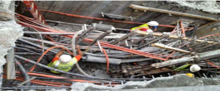
Seismic Acquisition
Makamin, in collaboration with its partner company, GSC, operates with cutting-edge seismic equipment and advanced technology. The company actively receives support from the top US seismic exploration technology input/output company.
Recently, GSC-UK acquired innovative seismic field equipment with the help of their partnership and support from INOVA USA. The equipment can record up to 6000 channels of 2D/3D using Vibroseis or Dynamite methods. In addition, the company uses the latest third-generation full-wave digital 3D component Vectorseis geophones, which accurately record P and S waves.
GSC-UK constantly seeks opportunities to expand its activities and services and is interested in joint ventures in the region. Their services portfolio includes Seismic Reflection of 2D/3D/4D, Shallow Seismic Reflection, Seismic Refraction, and High-Resolution Seismic Reflection.


Seismic Data Processing
The company is an expert in seismic data processing and interpretation, with an impressive 35-year track record of delivering results worldwide. Their team of skilled explorationists has processed and interpreted tens of thousands of kilometers of 2D and 3D seismic data from various regions across the globe, making them a reliable partner for any project.
As explorationists themselves, the company understands the importance of timely, high-quality data analysis. With this in mind, they offer a range of advanced processing technologies that can help increase the signal-to-noise ratio of seismic data, improve the continuity of geological horizons, remove false geological features, derive accurate velocities for stacking and depth migration, extract suitable wavelets for seismic deconvolution, preserve relative amplitude for direct hydrocarbon indication, and migrate and dip-move-out seismic data to tie VSP and well logs.
Their team boasts in-depth knowledge of signal analysis for seismic applications and has a solid background in the field, making them the perfect choice for anyone looking for expert assistance in producing a true geological section. By working hand-in-hand with clients, the team can deliver high-quality results needed to achieve project success.
Seismic Data Interpretation
“Our company offers a diverse range of essential services that are applicable to various industries. Our team of experts specializes in Depth-to-Bedrock Surveying and Mapping, which entails conducting thorough surveys to determine the bedrock depth of a specific area. Additionally, we offer Soil Sequence Stratigraphy Imaging and Mapping, which enables us to classify various types of soil, including sand, gravel, clay, boulders, silt, and cobbles.
We also provide In-Situ Material Properties Testing utilizing cutting-edge methods such as shear-wave analysis, electrical resistivity, and rock rippability to evaluate the underlying material’s properties.
Our team also possesses extensive experience in 3-D Subsurface Imaging and Mapping, Buried Object Detection, Void Detection/Imaging, as well as Shallow and Deep Oil/Gas Exploration. Furthermore, we offer Groundwater Exploration, a service that benefits many industries, along with Lake/River Bathymetry and Ice Thickness measurements.
With our expertise and experience, we can equip you with the information you require to make well-informed decisions about your projects.”

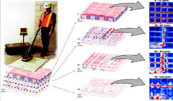
Shallow Geophysics
We offer services for studying what’s underneath the ground. This includes mapping the depth of the rock layer, figuring out what the soil is made of (like clay or sand), testing the strength of different materials, and creating 3D maps of what’s under the surface. We can also detect things that have been buried, find empty spaces, and explore for oil, gas, and water. Additionally, we can measure the depth of lakes and rivers, as well as how thick the ice is on top of them.
Geotechnical Site Investigation
Makamin is a company that offers invaluable assistance to geotechnical and civil engineers in need of in-depth site investigations. We provide essential shallow geophysical surveying services and analyze data to ensure that you have all the information you require to make informed decisions and recommendations on behalf of your clients. Our data results showcase subsurface information that is essential to completely understand the complex conditions of your project site. By increasing subsurface exploration coverage, we can help you provide better, more confident recommendations to clients, leading to enhanced project outcomes.
Our field tests provide a complete picture of the site conditions, from upper bedrock surface profiling/mapping to fault detection and mapping, void detection and mapping, and several other parameters. Our advanced geotechnical tests include soil characterization (clay, silt, sand, gravel, cobbles), soil/rock profile geometry, stiffness/hardness parameters, resistivity parameters, and soil sequence stratigraphy among others. Don’t hesitate to get in touch with Makamin and give your project the edge it needs.


Environmental Investigations
“Making is an industry leader in the utilization of advanced technologies that enhances our ability to detect subsurface environmental hazards or anthropogenic activity in the ground. Our state-of-the-art geophysics methodology is designed to identify, delineate, and map out complex geological and man-made features that are underground, providing our clients with critical information that can assist in identifying any potential environmental concerns. Our advanced technologies can detect various subsurface features, including landfill boundaries, buried drums, contaminated soils, graves, archaeological artifacts, remnant building foundations, buried pipelines, utilities, and conduits, as well as voids. Our team utilizes reliable and advanced imaging techniques that enable us to provide high-quality data to our clients, ensuring that they make informed decisions about their site. We use a comprehensive approach to environmental data analysis, combining various analytical techniques to deliver reliable and accurate results, and our team of experienced experts ensures that these results are delivered efficiently.”
Non-Seatructive Testing
Makamin is a company that can help you with projects that involve underground or existing infrastructure. They use special tools to measure things like the strength of materials, electrical activity, and how things are organized beneath concrete. They help you gather important data to make good decisions before starting a project, which can save you time and money. The people at Makamin have a lot of experience, and they use advanced technology to make sure the information they give you is accurate and helpful. If you need help with a project like this, you can contact Makamin to learn more about how they can assist you.


Land Survey
The Makamin Land Survey Department has dedicated itself to delivering exceptional services in surveying for the past decade. Collaborating with its partner company, GSC, the department stands out for consistently delivering high-quality results. It is fully equipped with robust resources that include the latest technology and equipment to support its well-educated and experienced technical staff. The department offers a wide range of services such as land surveying, levelling, topographic surveys, corridor alignments for both horizontal and vertical measurements, profile surveys, cadastral surveys, gate level computation services, demarcation services, and setting out surveys. Moreover, the department provides digital terrain modeling, settlement monitoring, earthworks volumes, underground utilities survey, as-built survey, establishment of control station and benchmarks, precise and differential leveling, survey consultancy, check engineering, crew hiring for surveys, aerial control mapping, laser, and 3D scanning. With such a comprehensive range of services, Makamin Land Survey Department has become a reliable name in the surveying industry.
GIS Services
“Makamin is a trusted provider of top-notch GIS services that use cutting-edge ESRI ArcGIS software, as well as other state-of-the-art software, to manage all sorts of geographically referenced information. Their expertise spans a wide range of GIS services, including geodatabase development, base mapping, and GPS data collection, among others. Makamin has a proven track record of delivering outstanding GIS results to an impressive list of clients that ranges from property developers and survey agencies to telecom and utility companies, municipalities, police departments, oil, and petroleum companies, consulting engineering firms, businesses, and educational institutes. One of the key strengths of Makamin is that it utilizes the power of GIS technology to provide customers with a deeper understanding of the data, which can have a profound impact on structures, watersheds, and virtually every aspect of engineered construction. Ultimately, Makamin helps customers solve a wide gamut of complex problems using cutting-edge GIS technology, while ensuring personalized service, attention to detail, and prompt delivery.”


Tap Transcription
Makamin is renowned for its exceptional expertise in tape transcription, which proves to be an essential service for clients involved in oil and gas exploration and beyond. The company offers unmatched services in scanning exploration data, seismic sections, maps, and logs, resulting in over 50,000 successfully transcribed seismic tapes. Moreover, Makamin’s partner (GSC) has been associated with NRA Jordan, Anadrako USA, Gulf Petroleum Qatar, Tate Neft Russia, ONGC, GPL India, Petrel, Pertamina Indonesia, and many more, which stands as a testament to the excellence of the services it provides.
Additionally, Makamin has a strong alliance with its sister companies and partners and can offer comprehensive solutions to fix even the most complicated tapes, including sticky, skewed ones. Makamin’s dedicated team of experts assures that quality is not compromised, and the company’s services can always be relied on for timely and efficient tape transcription solutions.
Consultancy and Localization
Makamin and its related companies in Jordan have been leaders in technology since they were created. They were the first to use Arabic on computers and they have the best technologies. Makamin has been working for more than 25 years on many different types of technological projects. They know how to work in the Middle East and understand the unique cultural and environmental challenges. Makamin ensures high-quality work and understands how to approach projects in different cultures. Clients benefit from Makamin’s expertise.


Training
ICS is a top-notch training and skills transfer service provider that has been helping its customers achieve their goals since 1978. On the other hand, GSC is known for being a leading expertise house that boasts a myriad of specializations. Meanwhile, Makamin Partners has been a go-to consultant in the oil exploration and geophysics analysis field for a long time. At Makamin, skill transfer is a prime component of their promise to help clients at all levels. The entity is renowned for its top-tier training facilities and methods that provide a fully equipped professional learning environment. They have a team of fully certified and experienced professionals who can go to customers’ premises to offer tailor-made training. Makamin’s consultants and educational consultants frequently work globally, servicing complex environments and implementing solutions. The trainers are knowledgeable in the practical uses of the technologies they teach, offering students the benefit of their expertise and approach to problem-solving. Overall, Makamin Partners’ goal is to help clients master their specialties, and their general tuition and laboratory classes provide clients with a comprehensive technical understanding of subjects.