
Adopted Technologies
WHAT MAKES MGS UNIQUE

Seismic Acquisition, Scorpion System
Scorpion is a field-proven land acquisition system designed to operate with geophones or with the industry-leading VectorSeis® 3C digital receivers for full-wave imaging. With flexible architecture and scalability, Scorpion accommodates the most challenging survey designs. Its user-friendly software and hardened ground electronics maximize operational productivity in any climate or terrain. Scorpion provides a high-channel-count recording platform complete with intuitive user interface, advanced telemetry features, fully-integrated source control, and functionality to increase field productivity and minimize overhead.
Scorpion accommodates a variety of survey design parameters, including: source-driven vibroseis, dynamite, or mixed-mode operations, efficient 2D, high-density 3D, or time-lapse 4D acquisition, hybrid analog and digital receiver spreads, and master/slave operations with ION’s cableless FireFly® and cable-based ARIES II, or other third-party systems. Additionally, Scorpion is fully integrated with ION’s Pelton source controllers, Vib Pro™, and Shot Pro™ II, to support advanced vibroseis fleet configurations and high-productivity dynamite acquisition.
Vectorseis SVSM Seismic Recever
“VectorSeis is the industry-leading, multi-component digital sensor for capturing the full seismic wavefield. Full-wave data is particularly important for imaging complex subsurface structures such as fractured shales, tight sands, and other unconventional plays. By utilizing three independent, orthogonally mounted MEMS (Micro Electro-Mechanical Systems) accelerometers, VectorSeis captures 3C seismic data while providing the productivity advantages of single-point receiver deployment and retrieval.”

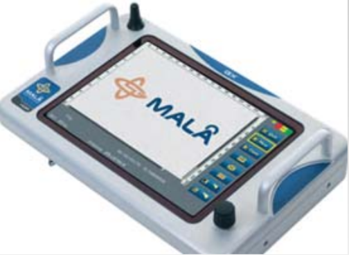
MALÅ GX450/160/80 HDR Solution
The MALÅ GroundExplorer (GX) is based on innovative, patent-pending MALÅ High Dynamic Range (HDR) technology and represents a leap forward in ground-penetrating radar. Advances in the design and construction of buried utilities have resulted in the ever-increasing use of non-metallic materials for which traditional locating technology does not work. Ground-penetrating radar offers a viable solution to this challenge as it is the only safe, non-invasive technology available that neither requires physical connection to the utility nor relies on electromagnetic (EM) radiation from the buried utility.
ADVANTAGES:
Ease of use, Exceptional detection capabilities, Outstanding signal-to-noise ratio and depth penetration, Significantly faster data acquisition rates, High-resolution display with excellent outdoor visibility, and Built-in battery and WiFi option removes cables, simplifies fieldwork.
ABEM Terraameter LS Imaging System
The ABEM Terrameter LS is a world-leading resistivity instrument that offers high-quality data. The instrument can be used for several applications and is developed to be useful for universities, contractors/consultants, governments, and aid organizations. As the Terrameter LS concept is modular, it offers individually tailored solutions to meet each client’s specific needs.
A major advantage of the electrical imaging method is that it produces continuous images of the variation in properties in the subsurface. This method can serve as an excellent basis for planning detailed investigations, for example, a drilling and sampling program with optimized sampling locations. The results of the detail investigation can then be used as a base for a refined interpretation of the electrical imaging data, leading to a comprehensive and reliable model of the underground.
Typical areas of application include groundwater resource management and vulnerability assessment, mapping and monitoring of contaminated ground/groundwater, geotechnical pre-investigation, geological mapping, mapping/prospecting of natural resources, geothermal prospecting, sub-bottom mapping at sea and in lakes, mapping of frozen ground/permafrost, and archaeology.


Geometrics Seismograph ES-3000
The ES-3000 system comes with all the necessary data analysis software required to conduct comprehensive refraction surveys to locate bedrock, the water table, suitable locations to rip, or to even outline gravel deposits. Geometrics provides special multi-license pricing for the standalone version of SeisImager/2D, enabling field crews and students to have their individual copies. The ES-3000 is backed by a three-year warranty from Geometrics, with almost 34 years of expertise and responsive customer support. Besides, the ES-3000 is available for rental and comes with the following features: locate bedrock, depth-to-water, faults, and fractures, making it appropriate for engineering, construction, road building, and teaching. Additionally, it provides top-quality data, automatic settings, lightweight, and low power with no complicated drivers. The ES-3000 includes analysis software to help you get quick answers in the field and reports for your client. Furthermore, it provides reduced noise and cost, replacing long, expensive analog cables with digital cables for data transmission between ES-3000 and host computer. Optional software for blast and vibration measurements, earthquake monitoring is also available.
ZEVS-36 Unit
High-speed unit for cleaning multipurpose heat exchangers and auxiliary application pipes. It is ideal for cleaning boilers with soft and medium scales. The special features include high-speed cleaning, the removal of any scaly deposits in pipes without damaging the equipment being cleaned. It can also clean bet and spiral pipes, and there are no wear parts. Two types of cable are included, and there is a ground fault circuit interrupter (GFI).
