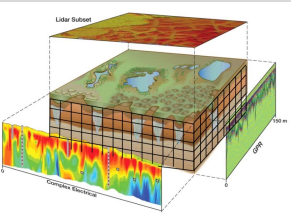
When it comes to conducting geological surveys for resource exploration or environmental studies, the process of borehole drilling has been a longstanding technique for gathering subsurface data. However, this method can be time-consuming and expensive, as it may take a whole day to complete just one or two drill holes. On the other hand, surface geophysics has been gaining popularity due to its capability of providing a much larger scale of subsurface imaging within the same time frame. By using this approach, hundreds or even thousands of linear horizontal meters can be sampled for a detailed analysis of the physical properties of the ground. This means that surface geophysics can provide a much wider and more accurate understanding of the geological structures, mineral deposits and groundwater resources of an area, which can be pivotal in making informed decisions on industrial, safety and environmental issues.