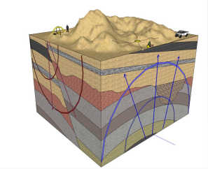
Consider using shallow geophysics to make intelligent planning and design decisions based on advanced knowledge of actual ground conditions that you will encounter on your next project, and not on guesswork. Shallow geophysics enables users to visualize underground features in between and beyond borehole locations. Where detailed information is required, surveys can be completed over gridded layouts to produce 3-Dimensional views of subterranean features. Makamin provides a broad range of shallow geophysical survey solutions for project engineers, geoscientists, and planners who require detailed information on subsurface conditions beneath their project areas. With over 20 years of experience through our partner companies in providing geophysical services to a wide range of industry groups on domestic and international projects, Makamin continues to offer clientele innovative solutions for their subsurface mapping needs.